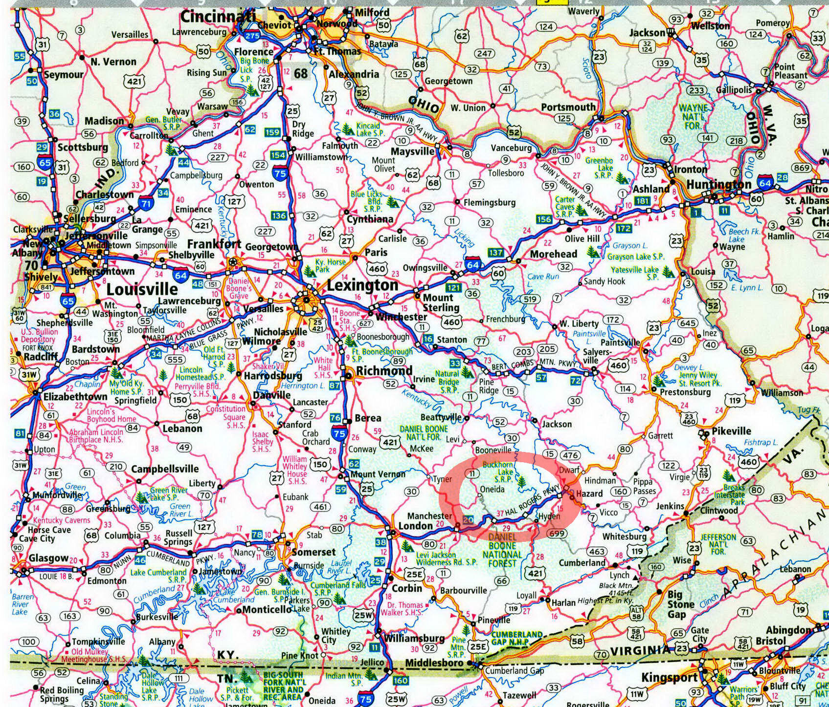
Buckhorn Campground in Kentucky on map

Buckhorn Campground
Walk-in tent sites are just one draw at this lake and river destination.
There is no easy way to reach Buck-horn Lake, but once you get here you will be rewarded. Here, the Middle Fork Kentucky River is dammed, forming a narrow, twisting, spindly snake of a lake. Visitors to this eastern Kentucky destination can enjoy not only the lake but also the tailwaters below the dam. It is below the dam, along these tailwaters, where Buckhorn Campground lies, enabling visitors to enjoy Buckhorn Lake and the river, too, along with some land-based recreation in these crumpled Kentucky mountains.
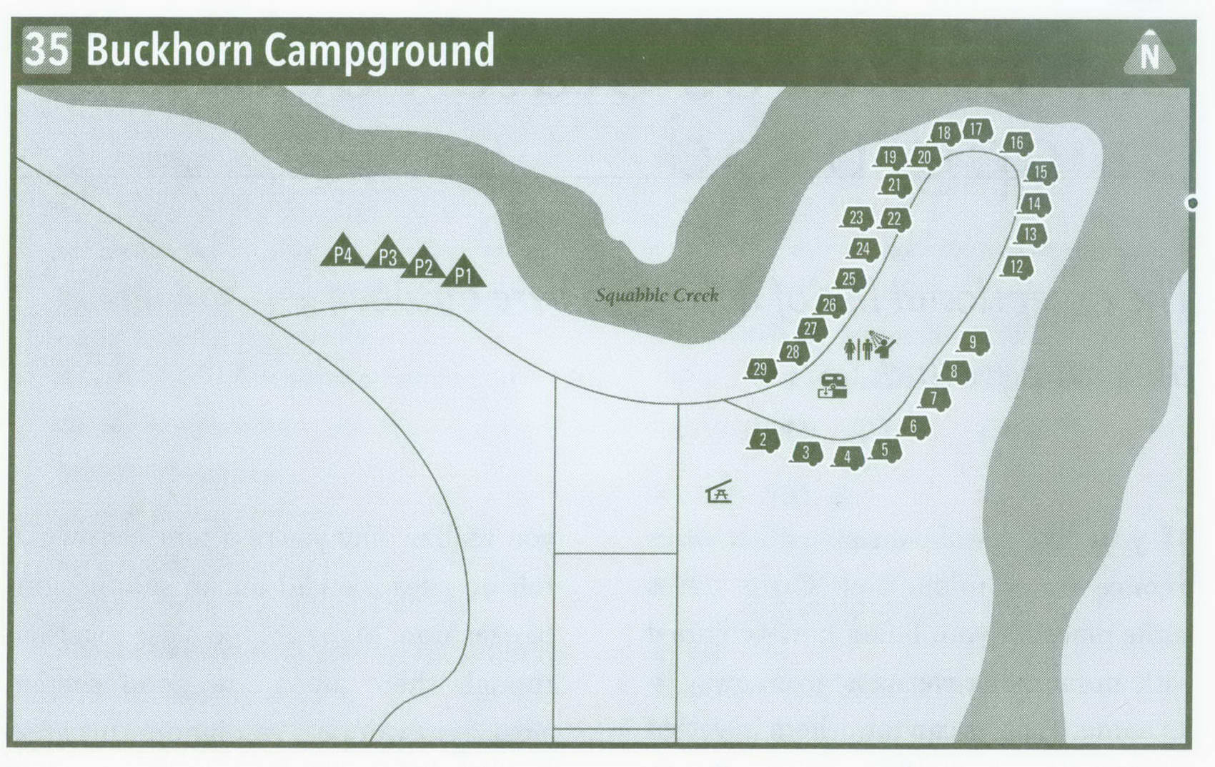
Squabble Creek makes a sharp horseshoe turn and meets the Middle Fork Kentucky River. Within this horseshoe lies the campground, a large, flat area surrounded on three sides by water. Pass the tollhouse, and you will notice this is a well-groomed, well-cared-for place to spend the night. The campground is set in a classic oval centered with a grassy field, where a bathhouse and horseshoe pits lie. Riverside sites begin immediately; little fences have been erected at each site to keep campers from falling into the land between the camp and the flowing river below. Sycamore and river birch trees grow near the river, and other planted trees shade the campground. A wooded ridge stands tall across the water. Thick grass grows between the sites. This cuts down on privacy, but all the sites are on the outside of the loop and decently spread apart. Starting with site 9, the sites are entirely shaded. As you reach site 14, begin to curve along Squabble Branch. Below here is a point where Squabble Branch meets the Middle Fork; this is a popular bank-fishing spot. More good campsites continue along Squabble Branch, including a couple of large double sites. The last set of sites becomes a little too open to the sun.
The walk-in tent sites are hard to find at first, located on the edge of the day-use parking area. Take a trail leading to these sites, which are situated above Squabble Creek. They are well shaded and offer more privacy than the main campground, but they're a little less than level. Still, they are much cheaper than the sites at the main campground. My favorite of the walk-ins is site 4. Near some pines, it is the largest and most level. A playground and two shelters are adjacent to the campground, so kids can have fun and tenters have a place to get out of the rain.
When water is emerging from the nearby dam spillway, you will hear it. Fishermen angle here for trout, which are stocked monthly. This is also a
jumping-off point for canoeists who want to ply the Middle Fork Kentucky River. The water flows directly past the campground, widening over distance but otherwise remaining attractive. This section is runnable almost all year, and access is good. Roads follow the river almost the entire way, making trips of varied lengths easy. Buckhorn Lake offers more boating and fishing activities.
This campground fills on nice summer weekends and holiday weekends, so reservations are recommended during these times. Buckhorn is a very safe camping area. It has an on-site campground host and is regularly patrolled by the sheriff and Corps of Engineers rangers. If you want to visit nearby Buckhorn Lake State Park, feel free to leave your stuff—it'll be there when you return.
There are land activities too. The Pine Shadows Nature Trail starts close to the walk-in tent sites and makes a loop below the dam. A second, longer hiking trail is the Stillhouse Branch Nature Trail. It starts near the boat launch on the lake side of the dam and climbs onto the nearby ridge, looping back down in its 2-plus-mile journey.
In keeping with this age, the campground is equipped with wireless Internet. Despite this, the walk-in sites still exude a primitive atmosphere. If you need something other than a device to surf the Internet from your campsite, the nearby village of Buckhorn has limited supplies.
Key Information about Buckhorn Campground
ADDRESS: 804 Buckhorn Dam Rd., Buckhorn, KY41721
OPERATED BY: U.S. Army Corps of Engineers
CONTACT: 606-398-7220, www. lrn. usace. army. mil ; reservations: 877-444-6777, reserveamerica . com
OPEN: Mid-April-mid-October
SITES: 4 walk-in, 24 others
SITE AMENITIES: Picnic tables, fire rings, and lantern posts (primitive sites); others also have upright grills, tent pads, water, electricity, and sewer
ASSIGNMENT: First come, first served and by reservation
REGISTRATION: At campground tollhouse
FACILITIES: Hot showers, flush toilets, laundry, wireless Internet
PARKING: At campsites and walk-in tent area
FEE: $12 walk-in, $22-$30 electric ELEVATION: 750 feet
RESTRICTIONS in Buckhorn Campground
¦ Pets: On leash only
¦ Fires: In fire rings only
¦ Alcohol: At campsites only
¦ Vehicles: Only on parking pads
¦ Other: 14-day stay limit in a 30-day stay period
Getting to Buckhorn Campground
From Exit 34 on Hal Rogers Parkway east of Manchester, take KY 66 South 0.5 mile to US 421. Turn left on US 421, and follow it south 4 miles to KY 1482. Turn left on KY 1482, and follow it north 8.4 miles to KY 484. Turn right on KY 484, and follow it 2.3 miles to KY 2022. Turn left on KY 2022, and follow it north 10.5 miles to KY 1387. Turn right on KY 1387, and follow it a short distance to reach the campground, on your left.
GPS COORDINATES N37° 20.650' W83° 28.215'
