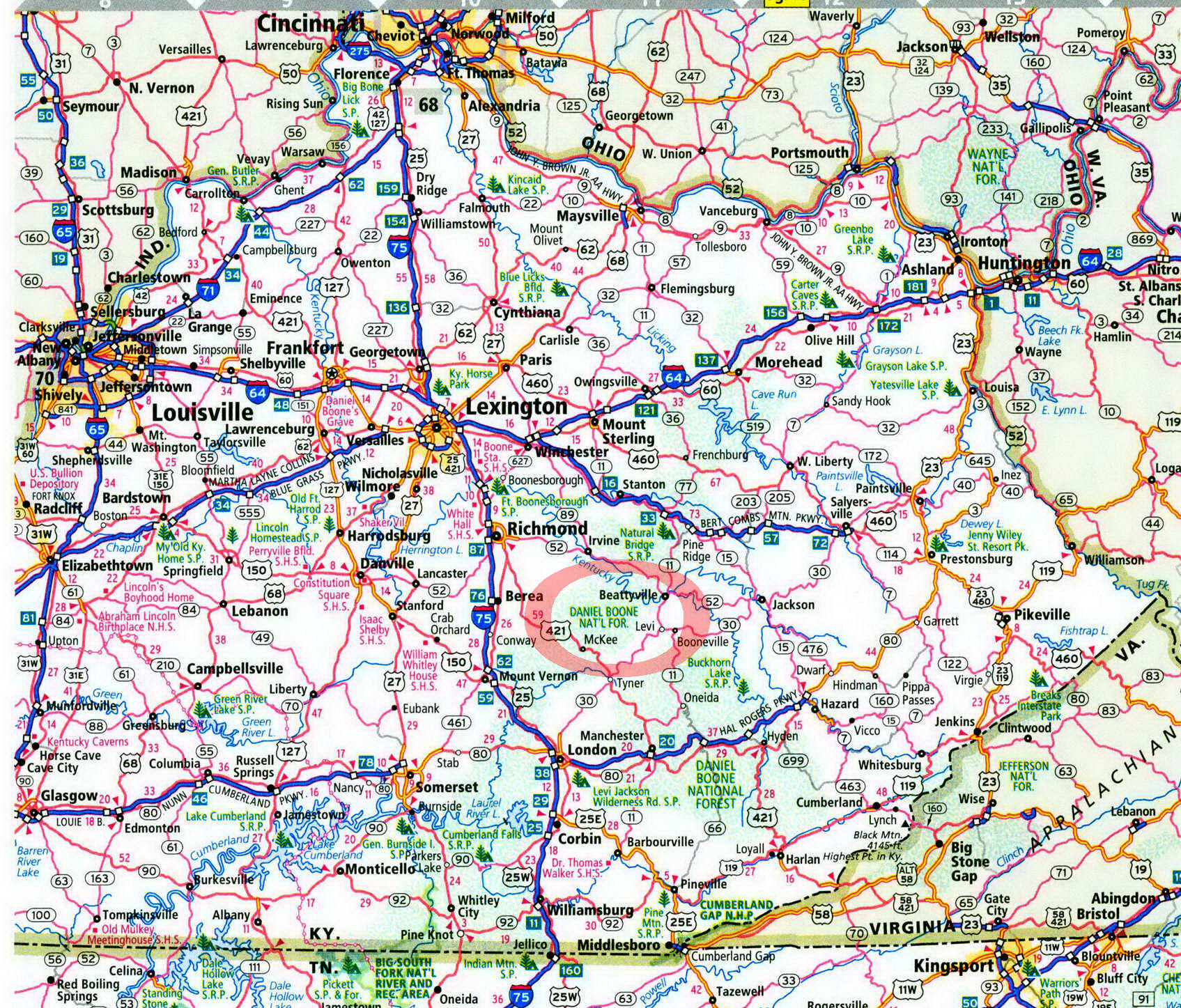
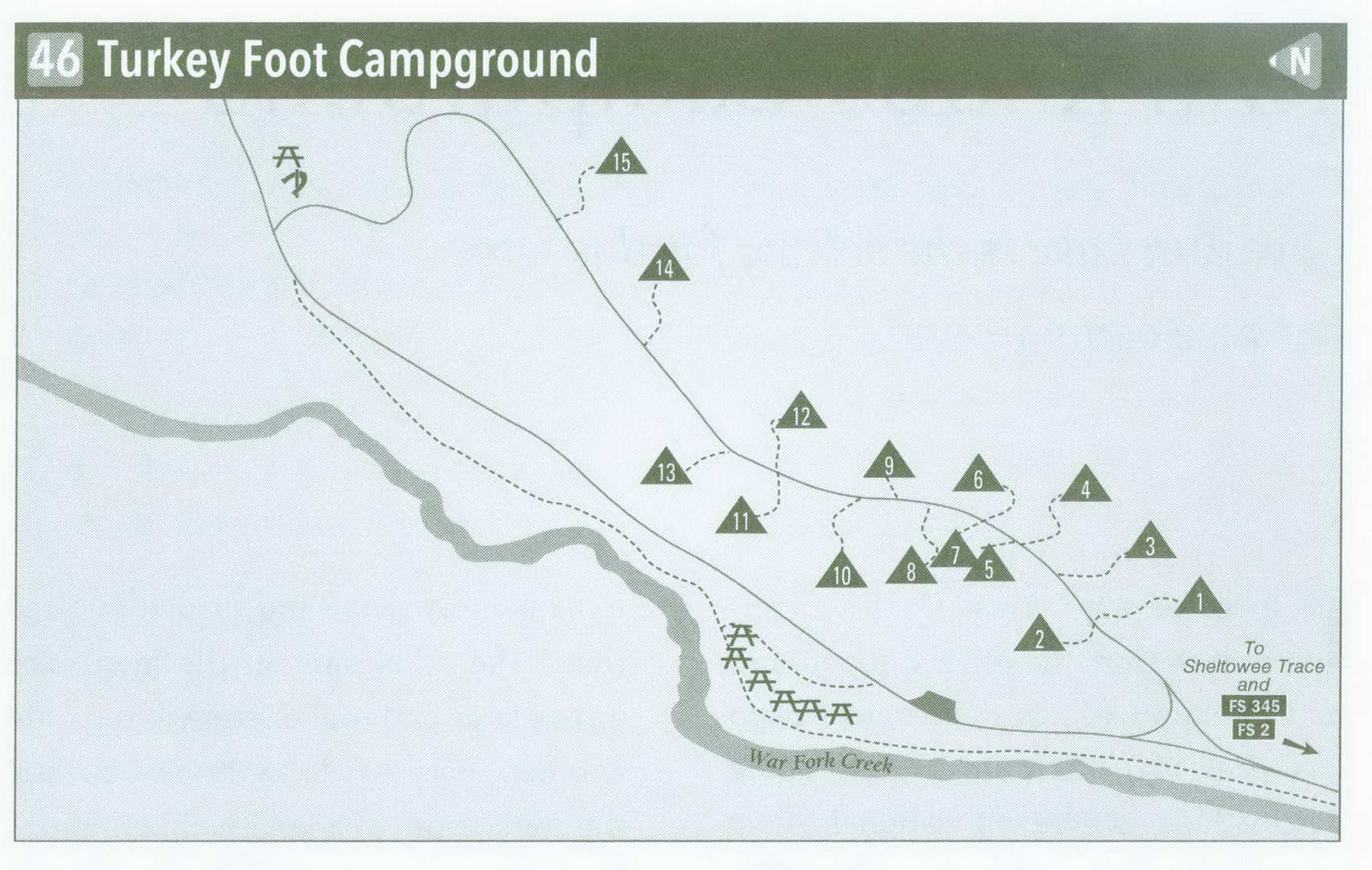
Turkey Foot Campground in Kentucky on map

Turkey Foot Campground
Little-used Turkey Foot lies in a quiet part of the Daniel Boone National Forest on the banks of War Fork Creek.
I camped at Turkey Foot on July 4. Normally shunning most campgrounds on such busy times, I figured this one would have sites available. I was right, sharing the 15-site campground with two other groups. (For the sake of full disclosure, heavy thunderstorms were predicted for that day. They did come, but the day was far from a complete washout.) Turkey Foot is not near a big lake, nor does it have obvious recreation opportunities. Rather, this is an old-fashioned campground where you make your own fun. For me, it wasn't hard, with the Sheltowee Trace nearby and War Fork Creek for fishing.
From my view, the campground is just right. Cross a wet-weather bridge over War Fork Creek to enter the campground. Head up a hill and come to the first two campsites, nestled beneath a rich forest of hemlock, oak, and maple. A dense, brushy understory grows among the trees. The campground road then levels off on a bench above War Fork Creek. Landscaping timbers and old-time rockwork make for level sites. Most of those on the uphill side of the road are walk-in tent sites with stairs and steps leading to them. The sites on the downhill side are closer to your car and are more oriented toward pure car camping. Thick woods and plenty of distance separate the sites, offering the ultimate in privacy. The sites are generally spacious as well, offering plenty of room for even the most gear-laden tent camper. Plus, curvy roads and a lack of electrical hookups keep the big rigs away.
Keep down the campground road, and notice that some of the walk-in sites are far enough uphill to be unseen by other campers. About halfway along the gravel road are newer-style vault toilets. Come to the final site, 15, just as the campground road drops back downhill to the Turkey Foot picnic area, which lies on a streamside flat overlooking War Fork Creek. A field with a horseshoe pit is adjacent to the picnic area. Turkey Foot campground fills only infrequently; there are no reservations, no registration, and no fees. The price is right. And in this case, you get more than what you pay for. Come here for solitude, and come here on a holiday if you want a site. But remember: you have to make your own fun.
I rolled in about noon, setting up my Kelty Tent just as the skies were darkening. I took a little nap as the storm passed through, then walked the campground loop road while water dripped from the trees. The air had cooled to the 60s, so I decided to take a hike. Just across the campground bridge is a trail accessing
Kentucky's master footpath, the Shel-towee Trace. I turned right and took it north for 2 miles, crossing Forest Road 345 a couple of times before dropping once again to War Fork. The trail bisected War Fork here. Resurgence Cave stood on the left bank just at the crossing. The cave got this name from the water that flows from the dark cavern, filling the sometimes-dry streambed of War Fork. Fog hovered over the chilly water as it filled the streambed. Downstream were bluffs and other rock formations. This is also good fishing territory. In spring, War Fork is stocked with trout and offers angling for cold-water-loving fish and smallmouth bass.
If you want to see Resurgence Cave the easy way, take a right out of the campground on FS 345 and drive 2 miles. Look for a dirt road leading downhill to the right. There is a small parking area where the unmarked dirt road meets the Shel-towee Trace. Take the Trace downhill just a short distance to War Fork and the cave. War Fork flows year-round below Resurgence Cave; it sometimes goes underground between the campground and the cave, but nice swimming pools flow year-round at the Turkey Foot picnic area. Stone steps lead down to the water here. The Sheltowee Trace also leaves south from the campground and climbs the drainage of Middle Fork to reach Forest Road 376 after 3.7 miles. You probably won't see anyone on this section of trail— and you may not see anyone else at Turkey Foot for that matter.
Key Information about Turkey Foot Campground
ADDRESS: 761 South Laurel Rd.,
London, KY 40744
OPERATED BY: U.S. Forest Service
CONTACT: 606-864-4163, www . fs . usda .gov / dbnf
OPEN: Mid-April-mid-November
SITES: 15
SITE AMENITIES: Picnic table, fire ring, lantern post, tent pad
ASSIGNMENT: First come, first served; no reservations
REGISTRATION: No registration
FACILITIES: Vault toilets (bring your own water)
PARKING: At campsites only FEE: None
ELEVATION: 900 feet
RESTRICTIONS in Turkey Foot Campground
¦ Pets: On 6-foot leash only
¦ Fires: In fire rings only
¦ Alcohol: At campsites only
¦ Vehicles: No more than 2 per site
¦ Other: No trash cans-pack it in, pack it out
Getting to Turkey Foot Campground
From Exit 76 on 1-75 near Berea, head east on US 421 18 miles to McKee. Once in McKee, turn left on KY 89, passing through the town square. Follow KY 89 North 3 miles to a sharp, signed right turn onto paved Forest Service Road 17. Follow FS 17 0.5 mile, turning left onto a paved road that becomes FS 2 after 1 mile. Continue forward on gravel FS 2 2 more miles to FS 345. Turn left onto FS 345, and follow it 0.2 mile to the right turn into Turkey Foot.
GPS COORDINATES N37° 28.004' W83° 55.018'
