Birmingham Ferry-Smith Bay Campground in Kentucky on map
Birmingham Ferry-Smith Bay Campground
Birmingham Ferry-Smith Bay Campground.
Pick your favorite bay on Kentucky Lake.
The north end of the Land Between the Lakes, or LBL, is really more than land between Kentucky Lake and Lake Barkley—in fact, "Land Darn Near Encircled by Lakes" might be a more appropriate description. The area is enveloped on three sides by water, as Lake Barkley not only covers the land's eastern flank but also curves around and circles its northern side. Kentucky Lake forms the western border.
Like the rest of the LBL, the north end is rife with recreational opportunities. Birmingham Ferry and Smith Bay are two small, closely situated campgrounds, each on a bay of Kentucky Lake and separated by a low ridge. They are now designated as backcountry camping areas, despite still being campgrounds. What this means is that you pay a per-camper backcountry camping fee, rather than a nightly fee. Moderately sized and rustic, both have many lakeside campsites. All sorts of watery recreation opportunities are at hand, with trails for mountain bikers just a pedal away. These trails are open to hikers as well.
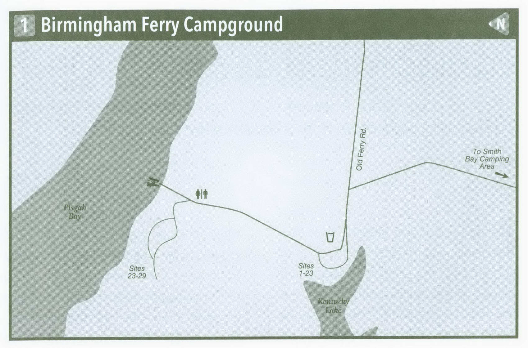
Old Ferry Road ends near Kentucky Lake and enters the campground. The first couple of sites in the loop are wide open and away from the lake, a whole 100 feet from the water. A few trees begin to shade some of the later sites; then the loop turns left toward the water. Here are seven large, somewhat open sites directly on the water.
In the middle of the loop, a road continues away from the water. Climb a small ridge on this road and dip again to the lake, this time into Pisgah Bay. Drop down to the water to find two isolated sites right on the lake (boaters claim these early). Pass the boat ramp and boater parking area, and come to an unlikely loop on an ultra steep hill. Here are two sites on a bluff with great water views. But make sure to stake your tent down, or you might take a tumble down the bluff. (Note: These sites are not suitable for kids.) Swing around and climb higher on the hill to a couple more sites on a more reasonable slope. The sites themselves have been leveled.
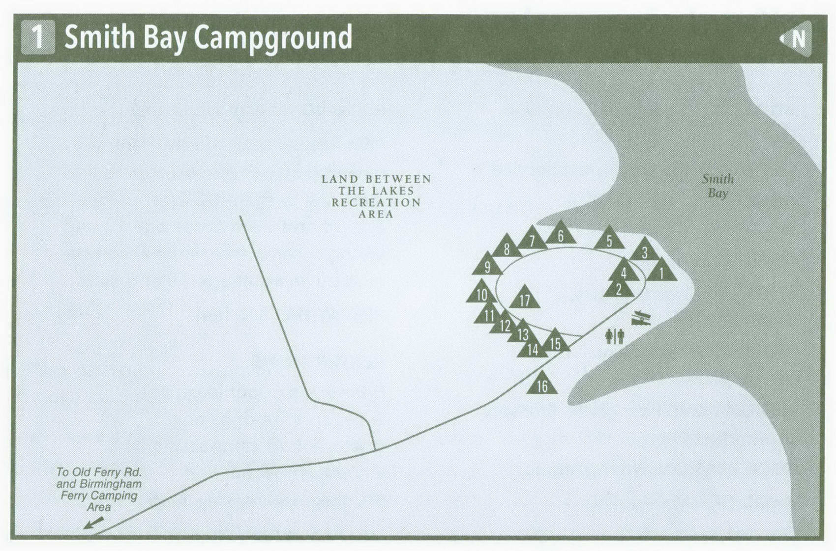
Nearby, just a ridge over to the south, is the Smith Bay Camping Area. You may want to look this over before you make your final campsite decision. Pass site 16, all by itself on the water, and then come to the boat launch. Enter the main campground. It is very open but usually has a shade tree or two to keep the sun at bay.
A string of seven sites is located lakeside; then the sites turn away from the water. The sites up the hill are better shaded but still have a view of Smith Bay This campground, like Birmingham Ferry, has convenient vault toilets and a water spigot.
Water recreation is just a walk away from your tent from either campground; boating, fishing, and swimming are likely choices. The reason I prefer Birmingham Ferry is its added land-based recreation. The North-South Trail crosses Old Ferry Road just a half mile from the campground. This section of the trail is open to hikers and mountain bikers, so you can pedal straight from the campground. Head south toward Hatchery Hollow and the Nature Station Connector Trail, where there are paths aplenty.
Key Information about BIRMINGHAM FERRY-SMITH BAY CAMPGROUND
ADDRESS: 238 Visitor Center Dr., Golden Pond, KY 42211
OPERATED BY: U.S. Forest Service
CONTACT: 800-LBL-7077, landbetweenthelakes . us
OPEN: Year-round
SITES: Birmingham Ferry, 29; Smith Bay, 17
SITE AMENITIES: Picnic table, fire grate
ASSIGNMENT: First come, first served; no reservations
REGISTRATION: No registration FACILITIES: Vault toilets
PARKING: At campsites only
FEE: Annual backcountry camping permit, $30 per person age 18 and over; 3-Day Permit, $7 per person age 18 and over; those age 17 and younger camp free when accompanied by an adult age 18 and over.
ELEVATION: 360 feet
RESTRICTIONS in Birmingham Ferry-Smith Bay Campground
¦ Pets: On 6-foot leash only
¦ Fires: In fire rings only
¦ Alcohol: At campsites only
¦ Vehicles: None
¦ Other: 14-day stay limit
If you head north, you will come to a side trail reaching Nightriders Spring, then a paved hiking and biking trail that makes a loop out of Hillmans Ferry. Farther north are the Canal Loop trails. A series of connector trails makes loop routes possible here, ranging from 1.5 miles to 10 or more miles. Wear yourself out, but first get a trail map at the LBL north entrance station to know where you are going. After a tent-camping adventure at Birmingham Ferry, you are going to tell your friends and you are going to come back for more.
Getting to Birmingham Ferry-Smith Bay Campground
From Exit 31 on I-24 near Lake City, head south on KY 453 for 11.7 miles, intersecting The Trace along the way to reach Old Ferry Road (Forest Service Road 114). Turn right on Old Ferry Road and follow it 3.5 miles to dead-end at the campground.
GPS COORDINATES N36° 55.354' W88° 9.657'

