Ecuador geographic map
Geography map of Ecuador
Geographic map of Ecuador with the terrain. Big map of Ecuador with a
brief historical outline and full of geographic data about the South
American country of Ecuador.
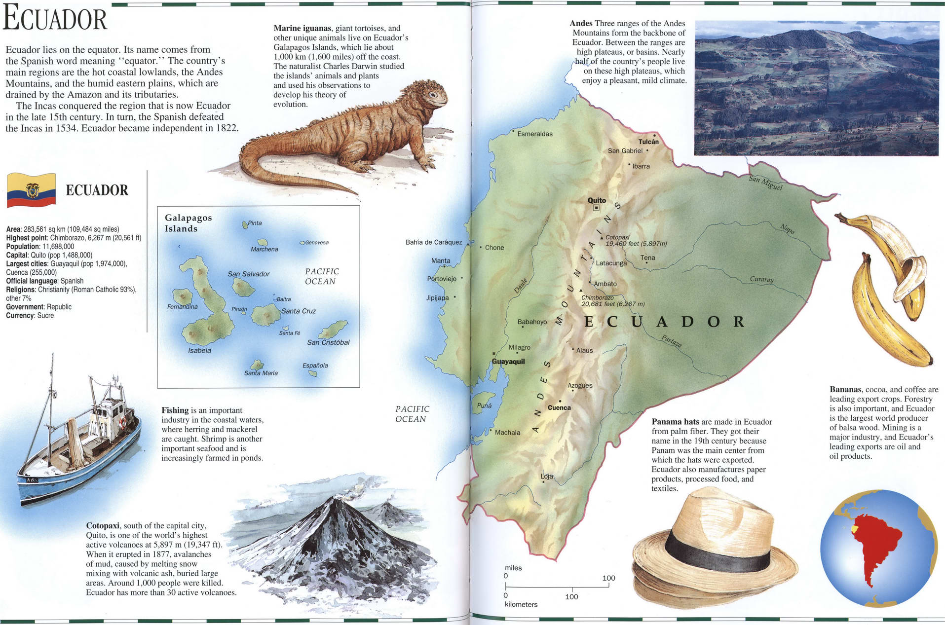
Ecuador geographical description
Ecuador lies on the equator. lis name comes from the Spanish word meaning "equator." The country's main regions are the hot coastal lowlands, the Andes Mountains, and the humid eastern plains, which are drained by the Amazon and its tributaries.
The Incas conquered the region that is now Ecuador in the late 15th century. In turn, the Spanish defeated the Incas in 1534. Ecuador became independent in 1822.
Marine iguanas, giant tortoises, and Other unique animals live on Ecuador's Galapagos Islands, which lie about 1,000 km (1.600 miles) off the coast. The naturalist Charles Darwin studied the islands' animals and plains and used his observations lo develop his theory of evolution.
ECUADOR highlights
Area: 283,561 sq km (109,484 sq miles)
Highest point: Chimborazo. 6,267 m (20.561 ft)
Population: 11,698,000
Capital: Quito (pop 1,488,000)
Largest cities: Guayaquil (pop 1.974,000). Cuenca (255.000)
Official language: Spanish
Religions: Christianity (Roman Catholic 93%), other 7%
Government: Republic Currency: Sucre
Fishing is an important industry in the coastal waters, where herring and mackerel are caught. Shrimp is another important seafood and is increasingly farmed in ponds.
Cotopaxi. south of the capital city, Quito, is one of the world's highest active volcanoes at 5,897 m (19.347 ft). When it erupted in 1877. avalanches of mud. caused by melting snow mixing with volcanic ash, buried large areas. Around 1,000 people were killed, Ecuador has more than 30 active volcanoes.
Andes Three ranges of the Andes Mountains form the backbone of Ecuador. Between the ranges are high plateaus, or basins. Nearly >f the country's people live on these high plateaus, which enjoy a pleasant, mild climate.
Panama hats are made in Ecuador from palm liber. They got their name in the 19th century because Panam was the main center from which the hats were exported. Ecuador also manufactures paper products, processed food, and textiles.
Bananas, cocoa, and coffee are leading export crops. Forestry is also important, and Ecuador is the largest world producer of balsa wood. Mining is a major industry, and Ecuador's leading exports are oil and oil products.