South America detailed map
Map of South America
Atlas of maps of South America. Detailed large scale geographic and political maps of states of South America.
Detailed map of the terrain of South America. Detailed visual map of the relief of the continent of South America.
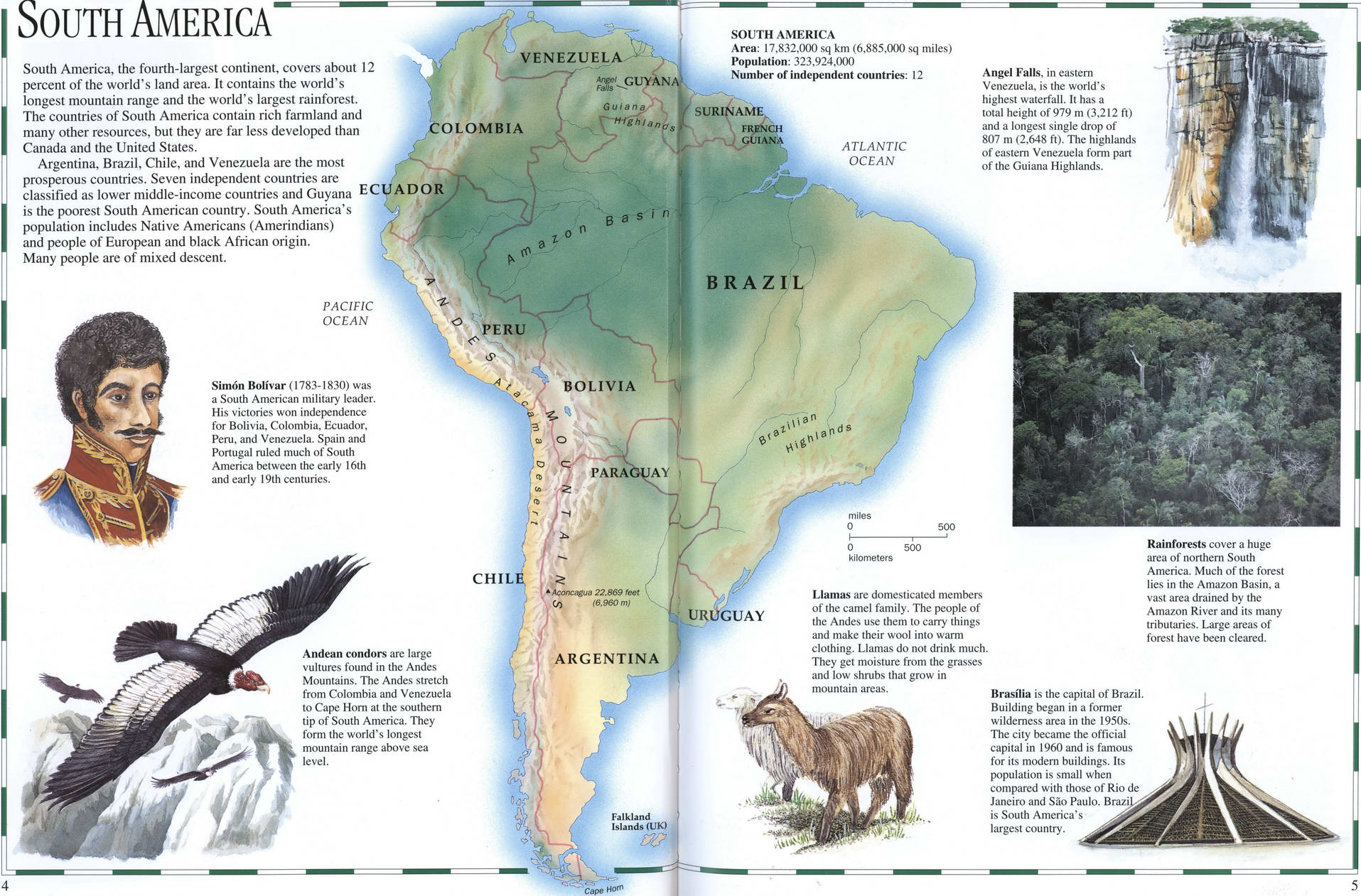
South America, the fourth-largest continent, covers about 12 percent of the world's land area. It contains the world's longest mountain range and the world's largest rainforest. The countries of South America contain rich farmland and many other resources, but they are far less developed than Canada and the United States.
Argentina, Brazil. Chile, and Venezuela are the most prosperous countries. Seven independent countries are classified as lower middle-income countries and Guyana E is the poorest South American country. South America's population includes Native Americans (Amerindians) and people of European and black African origin. Many people are of mixed descent.
Atlas of SOUTH AMERICA
Area: 17.832,000 sq km (6.885.000 sq miles) Population: 323.924.000 Number of independent countries: 12
Angel Falls, in eastern Venezuela, is the world's highest waterfall. It has a total height of 979 m (3.212 ft) and a longest single drop of 807 m (2,648 ft). The highlands of eastern Venezuela form part of the Guiana Highlands.
Simon Bolivar (1783-1830) was a South American military leader. His victories won independence for Bolivia. Colombia. Ecuador. Peru, and Venezuela. Spain and Portugal ruled much of South America between the early 16th and early 19th centuries.
Andean condors arc large vultures found in the Andes Mountains. The Andes stretch from Colombia and Venezuela to Cape Horn at the southern tip of South America. They form the world's longest mountain range above sea level.
Mamas are domesticated members of the camel family. The people of the Andes use them to carry things and make their wool into warm clothing. Llamas do not drink much. They get moisture from the grasses and low shrubs that grow in mountain areas.
Rainforests cover a huge area of northern South America. Much of the forest lies in the Amazon Basin, a vast area drained by the Amazon River and its many tributaries. Large areas of forest have been cleared.
Brasilia is the capital of Brazil Building began in a former wilderness area in the 1950s. The city became the official capital in I960 and is famous for its modem buildings. Its population is small when compared with those of Rio de Janeiro and Sao Paulo. Brazil is South America's largest country.