Peru geographic map. Detailed map of Peru with description. Peru on the world map.
Geographical map of Peru. Detailed map of Peru with a brief description of the country. Peru on the world map.
Geographic map of Peru. Full information about Peru on one geographical map with cities, rivers, mountains and places of interest.
Geography map Peru. Brief description of Peru: nature, climate, population, industry, agriculture. Free detailed printable geographic map of Peru.

Peru geographic description
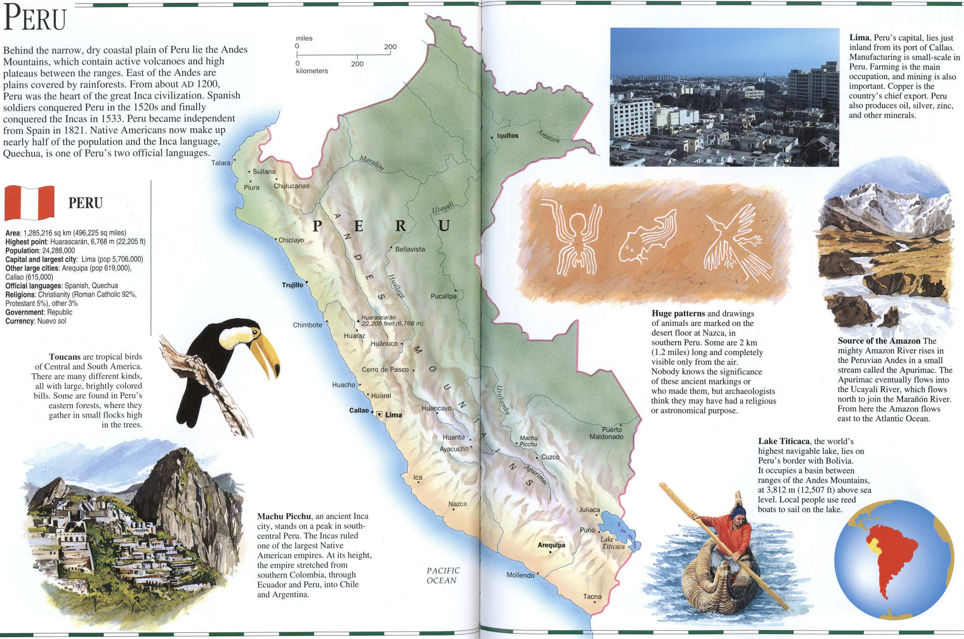
Behind the narrow, dry coastal plain of Peru lie Ihe Andes Mountains, which contain active volcanoes and high plateaus between the ranges. East of the Andes are plains covered by rainforests. From about AD 1200. Peru was the heart of the great Inca civilization. Spanish soldiers conquered Peru in the 1520s and finally conquered the Incas in 1533. Peru became independent from Spain in 1821. Native Americans now make up nearly half of the population and the Inca language, Quechua, is one of Peru's two official languages.
Lima, Peru's capital, lies just inland from its port of Callao. Manufacturing is small-scale in Peru. Farming is the main occupation, and mining is also important. Copper is the country's chief export. Peru also produces oil. silver, zinc, and other minerals.
Area: 1,285.216 sq km (496.225 sq miles) Highest point: Huarascaran, 6,768 m (22.205 ft) Population: 24,286.000 Capital and largest city: Lima (pop 5.706.000) Other large cities: Arequipa (pop 619.000). Callao (615.000)
Official languages Spanish, Quechua Religions: Chnstianity (Roman Catholic 92%. Protestant 5%). other 3% Government: Republic Currency: Nuevo sol Toucans are tropical birds of Central and South America. There arc many different kinds, all with large, brightly colored bills. Some are found in Peru's eastern forests, where they gather in small Hocks high in the trees.
Source of the Amazon The mighty Amazon River rises in the Peruvian Andes in a small stream called the Apurimac. The Apurimac eventually flows into the Ucayali River, which flows north to join the Maran6n River. From here the Amazon flows east to the Atlantic Ocean.
Machu Picchu. an ancient Inca city, stands on a peak in south-central Peru. The Ineas ruled one of the largest Native American empires. At its height the empire stretched from southern Colombia, through Ecuador and Peru, into Chile and Argentina.
Huge patterns and drawings of animals arc marked on the desert floor at Na/ca. in southern Peru. Some are 2 km (1.2 miles) long and completely visible only from the air. Nobody knows the significance of these ancient markings or who made them, but archaeologists think they may have had a religious or astronomical purpose.
Lake Titicaca. the world's highest navigable lake, lies on Peru's border with Bolivia. It occupies a basin between ranges of the Andes Mountains, at 3.812 m (12.507 ft) above sea level. Local people use reed boats to sail on the lake,
